FAQ
Service unavailable
If the web site keeps reporting Service unavailable, the cause could be memory allocation issues on the web site.
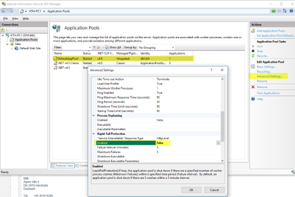
To force the website to keep running even when errors occur, turn off Rapid-Fail Protection on the app pool (below image assumes that the DefaultAppPool is used).
Using available memory
The website is configured to use 50% of the installed memory. In cases where lots of memory is available (> 8Gb), the amount of memory can be increased.
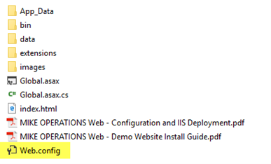
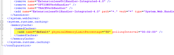
The Web.config file, found in the root of the website folder, contains a setting physicalMemoryLimitPercentage.
Increase this number to use more memory, and decrease the memory use if the server containing the website, does not have that much memory (< 4Gb).
Optimizing visualization of meshes and grids
When running animations, visualizing of meshes (dfsu) and grids (dfs2), is a processing heavy operation, as a new image is created for each time step at runtime.
The processing of the image is using every available CPU’s (cores) on the web server to make the animation as smooth as possible.
If the animation is not running smooth or if the animation is flickering, note the following to find the cause:
- Check the Network throughput using the Windows Task Manager. Dfsu and dsf2 files should be placed on the web server, to minimize the network traffic. Especially when using large files.
- Check the CPU Utilization using the Windows Task Manager. The more CPU’s (cores) on the web server the better, as the image processing is using all available CPU’s.
- Check the memory usage using the Windows Task Manager. To minimize hard disk operations, make sure that not all memory of the server is used. Add more RAM to the server if needed.
- Check the disk activity using the Windows Task Manager. A lot of activity can be solved by more RAM and/or a SSD. A Solid State Drive (SSD) is much faster than an ordinary hard disk.
- Check the number of elements in the dfsu and dfs2 files. Reduce the number of elements in the files if possible.
- Set the projection of the dfsu and dfs2 files to Web Mercator, to prevent a reprojection of the files during the image generation.
HTTP Error 500.19 - Internal Server Error
When installing MIKE OPERATIONS Web on Windows Server 2016 or Windows Server 2019, an internal server error could be shown when trying to access the website configured.
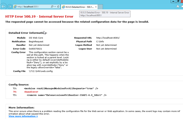
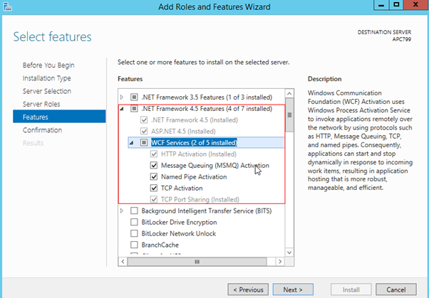
The reason for this can be that WCF Services is not installed, as WCF services is not activated by default when installing Windows Server 2016 or Windows Server 2019.
To activate WCF services:
- Login as administrator on the server.
- Select Start -> Server Manager
- In Server Manager, select Manage -> Add Roles and Features
- Expand .Net Framework 4.5 Features
- Select WCF Services
Creating custom Symbology for dfs2 and dfsu files
By default, the symbology of dfs2 and dfsu files on MO Web, is applied using a rainbow pattern, dividing the largest and the smallest value the mesh or grid into 10 intervals.
This symbology can be customized using xml files placed with the dfsu or dfs2 file.
The name of the xml file should contain both the name of the file and the name of the item like this.
<dfs file name>.<item name>.symbology.xml

The xml file can be made manually or can be generated using a remote file based raster provider in the GIS Manager of MIKE WORKBENCH.
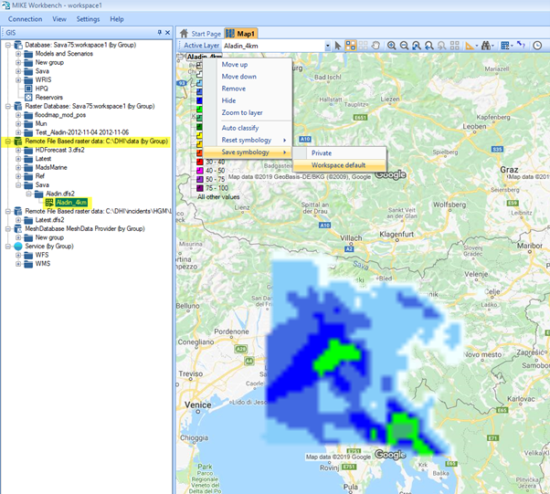
Figure 1 - Save symbology file using a remote file based raster provider
Two types of symbology xml files are supported:
Gradient symbology type
The gradient symbology type allows specifying the minimum value and the maximum value, a colour gradient range the number of intervals.
<RasterLayerDefinition StyleType="Simple" RasterStyleType="Gradient" Name="Water depth" IsVisible="True" OwnOverlay="False" ShowInLegend="True" DisplayMapScale="1:18,023" IsPublic="True">
    <LayerStyleDefinition OuterLineType="Solid" Unit="m" LowerValue="0" LowerValueColor="Color [White]" UpperValue="5" UpperValueColor="Color [Blue]" NumOfIntervals="10" NoValueColor="Color [Transparent]" Color="Color [Black]" OuterLineColor="Color [Black]" OuterLineThickness="1" Transparency="0" />
    <LayerScaleRange />
</RasterLayerDefinition>
Value Range symbology type
The value ranges symbology type allows specifying every value range and the colour of the value range.
<RasterLayerDefinition StyleType="Simple" RasterStyleType="ValueRanges" Name="Aladin_4km" IsVisible="True" OwnOverlay="False" ShowInLegend="True" DisplayMapScale="1:2,306,999" IsPublic="True">
    <LayerStyleDefinition Attribute="" BaseColor="Color [Black]" ResetMaxMin="True" NumOfIntervals="15" Color="Color [Transparent]" Unit="mm" Transparency="0" ColorTransparency="0" OuterLineType="Solid" OuterLineThickness="1">
        <ValueRangeStyleDefinition MinValue="0" MaxValue="0.2" Color="Color [Transparent]" ColorTransparency="0" Label="" />
        <ValueRangeStyleDefinition MinValue="0.2" MaxValue="0.5" Color="Color [Azure]" ColorTransparency="0" Label="" />
        <ValueRangeStyleDefinition MinValue="0.5" MaxValue="1.5" Color="Color [LightSkyBlue]" ColorTransparency="0" Label="" />
        <ValueRangeStyleDefinition MinValue="1.5" MaxValue="2.5" Color="Color [RoyalBlue]" ColorTransparency="0" Label="" />
        <ValueRangeStyleDefinition MinValue="2.5" MaxValue="4" Color="Color [Blue]" ColorTransparency="0" Label="" />
        <ValueRangeStyleDefinition MinValue="4" MaxValue="6" Color="Color [Lime]" ColorTransparency="0" Label="" />
        <ValueRangeStyleDefinition MinValue="6" MaxValue="10" Color="Color [MediumSeaGreen]" ColorTransparency="0" Label="" />
        <ValueRangeStyleDefinition MinValue="10" MaxValue="15" Color="Color [Green]" ColorTransparency="0" Label="" />
        <ValueRangeStyleDefinition MinValue="15" MaxValue="20" Color="Color [Yellow]" ColorTransparency="0" Label="" />
        <ValueRangeStyleDefinition MinValue="20" MaxValue="25" Color="Color [Gold]" ColorTransparency="0" Label="" />
        <ValueRangeStyleDefinition MinValue="25" MaxValue="30" Color="Color [OrangeRed]" ColorTransparency="0" Label="" />
        <ValueRangeStyleDefinition MinValue="30" MaxValue="40" Color="Color [Red]" ColorTransparency="0" Label="" />
        <ValueRangeStyleDefinition MinValue="40" MaxValue="50" Color="Color [Magenta]" ColorTransparency="0" Label="" />
        <ValueRangeStyleDefinition MinValue="50" MaxValue="75" Color="Color [DarkOrchid]" ColorTransparency="0" Label="" />
        <ValueRangeStyleDefinition MinValue="75" MaxValue="100" Color="Color [Purple]" ColorTransparency="0" Label="" />
        <AllOtherValuesStyleDefinition />
    </LayerStyleDefinition>
    <LayerScaleRange />
</RasterLayerDefinition>
IIS Output Caching
Internet Information Services (IIS), supports configuring cache output, so that users using a website, will automatically get any updated file, without clearing the client cache.
Select Output Caching.
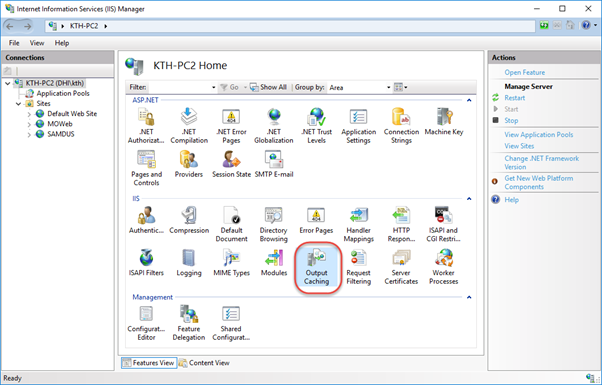
It is recommended to add output caching for the following file types for a web site containing MIKE OPERATIONS Web Classic:
*.htmlWeb pages.*.jsonConfiguration files.*.pngImages.